The New Georgia Encyclopedia is supported by funding from A More Perfect Union, a special initiative of the National Endowment for the Humanities.
Lula Lake and Lula Falls in Walker County showcase Georgia's natural geologic beauty, which draws visitors to the state each year.
Image from Jeff Moore
The New Georgia Encyclopedia does not hold the copyright for this media resource and can neither grant nor deny permission to republish or reproduce the image online or in print. All requests for permission to publish or reproduce the resource must be submitted to the rights holder.
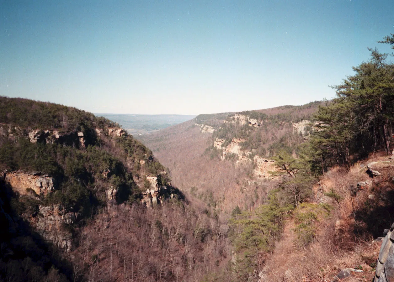
Exposed layers of sandstone are visible in the walls of Cloudland Canyon, part of the Appalachain Plateau geologic province in the northwest corner of Georgia. The vegetated slopes below the sandstone contain gray shale with interbedded sandstone, siderite, and coal.
Photograph by Pamela J. W. Gore
The New Georgia Encyclopedia does not hold the copyright for this media resource and can neither grant nor deny permission to republish or reproduce the image online or in print. All requests for permission to publish or reproduce the resource must be submitted to the rights holder.
Georgia encompasses parts of five distinct geographic regions: the Appalachian Plateau, the Valley and Ridge, the Blue Ridge, the Piedmont, and the Coastal Plain.
Courtesy of Pamela J. W. Gore
The New Georgia Encyclopedia does not hold the copyright for this media resource and can neither grant nor deny permission to republish or reproduce the image online or in print. All requests for permission to publish or reproduce the resource must be submitted to the rights holder.
High Falls is located along the fall line at High Falls State Park in Butts County. The fall line crosses the state from Augusta to Columbus and marks the point at which the hard rocks of the Piedmont meet the softer rocks of the Coastal Plain.
Image from Stephen Rahn
The New Georgia Encyclopedia does not hold the copyright for this media resource and can neither grant nor deny permission to republish or reproduce the image online or in print. All requests for permission to publish or reproduce the resource must be submitted to the rights holder.
The unconsolidated sandstone bluffs of Providence Canyon in Stewart County were formed during the Cretaceous Period and are among the oldest exposed Coastal Plains rock formations in the state.
Courtesy of Matthew M. Moye
The New Georgia Encyclopedia does not hold the copyright for this media resource and can neither grant nor deny permission to republish or reproduce the image online or in print. All requests for permission to publish or reproduce the resource must be submitted to the rights holder.
Sand dunes form along the coast of Cumberland Island off the coast of Georgia. Dunes are the primary geological feature of the state's barrier islands and represent the youngest geological deposits in the state.
Image from anoldent
The New Georgia Encyclopedia does not hold the copyright for this media resource and can neither grant nor deny permission to republish or reproduce the image online or in print. All requests for permission to publish or reproduce the resource must be submitted to the rights holder.
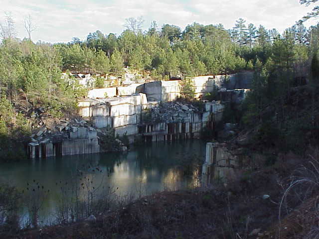
The Oglesby Quarry in Elberton, abandoned in 2003, is one of the many granite quarries to contribute to Georgia's economy. Formed approximately 1 billion years ago, granite is one of the oldest rock types found in Georgia.
Photograph by Clay Ouzts
The New Georgia Encyclopedia does not hold the copyright for this media resource and can neither grant nor deny permission to republish or reproduce the image online or in print. All requests for permission to publish or reproduce the resource must be submitted to the rights holder.
Tallulah Falls are today part of the Tallulah Gorge State Park in northeast Georgia.
Image from Rain0975
The New Georgia Encyclopedia does not hold the copyright for this media resource and can neither grant nor deny permission to republish or reproduce the image online or in print. All requests for permission to publish or reproduce the resource must be submitted to the rights holder.
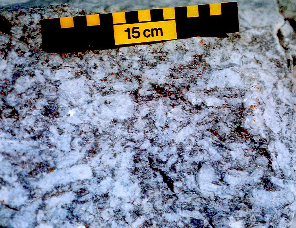
The Grenville gneisses were formed around 1 billion years ago during the Grenville Orogeny. The oldest rocks in Georgia, these gneisses form the "basement" upon which younger rocks were deposited during the formation of the Appalachian mountain chain.
Photograph by Pamela J. W. Gore
The New Georgia Encyclopedia does not hold the copyright for this media resource and can neither grant nor deny permission to republish or reproduce the image online or in print. All requests for permission to publish or reproduce the resource must be submitted to the rights holder.
Slate folds, which formed during the mountain-building events of the Paleozoic Era, are visible around Rockmart in the Valley and Ridge geologic province of northwest Georgia.
Photograph by Pamela J. W. Gore
The New Georgia Encyclopedia does not hold the copyright for this media resource and can neither grant nor deny permission to republish or reproduce the image online or in print. All requests for permission to publish or reproduce the resource must be submitted to the rights holder.
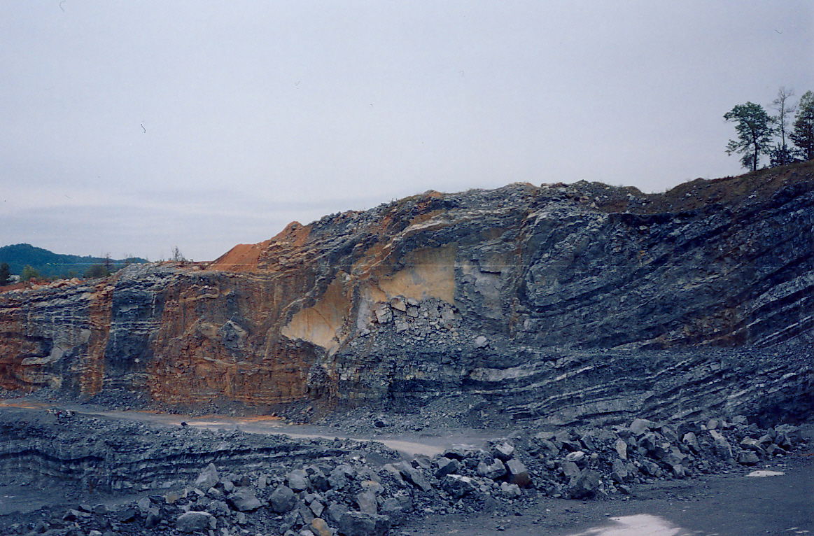
The Chattanooga Shale, located in northwest Georgia, was formed approximately 350 million years ago, when the area was covered by a shallow sea.
Photograph by Pamela J. W. Gore
The New Georgia Encyclopedia does not hold the copyright for this media resource and can neither grant nor deny permission to republish or reproduce the image online or in print. All requests for permission to publish or reproduce the resource must be submitted to the rights holder.
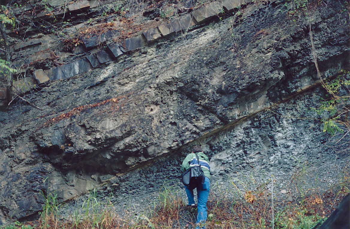
The Rising Fawn thrust fault, located in the Valley and Ridge geologic province of northwest Georgia, was formed during the Alleghanian orogeny, the third mountain-building event of the Paleozoic Era.
Photograph by Pamela J. W. Gore
The New Georgia Encyclopedia does not hold the copyright for this media resource and can neither grant nor deny permission to republish or reproduce the image online or in print. All requests for permission to publish or reproduce the resource must be submitted to the rights holder.
Stone Mountain Park encompasses 3,200 acres just sixteen miles east of downtown Atlanta. Formed around 300 million years ago during the Paleozoic Era, the mountain itself is the world's largest mass of exposed granite.
Image from Darryl Pierce
The New Georgia Encyclopedia does not hold the copyright for this media resource and can neither grant nor deny permission to republish or reproduce the image online or in print. All requests for permission to publish or reproduce the resource must be submitted to the rights holder.
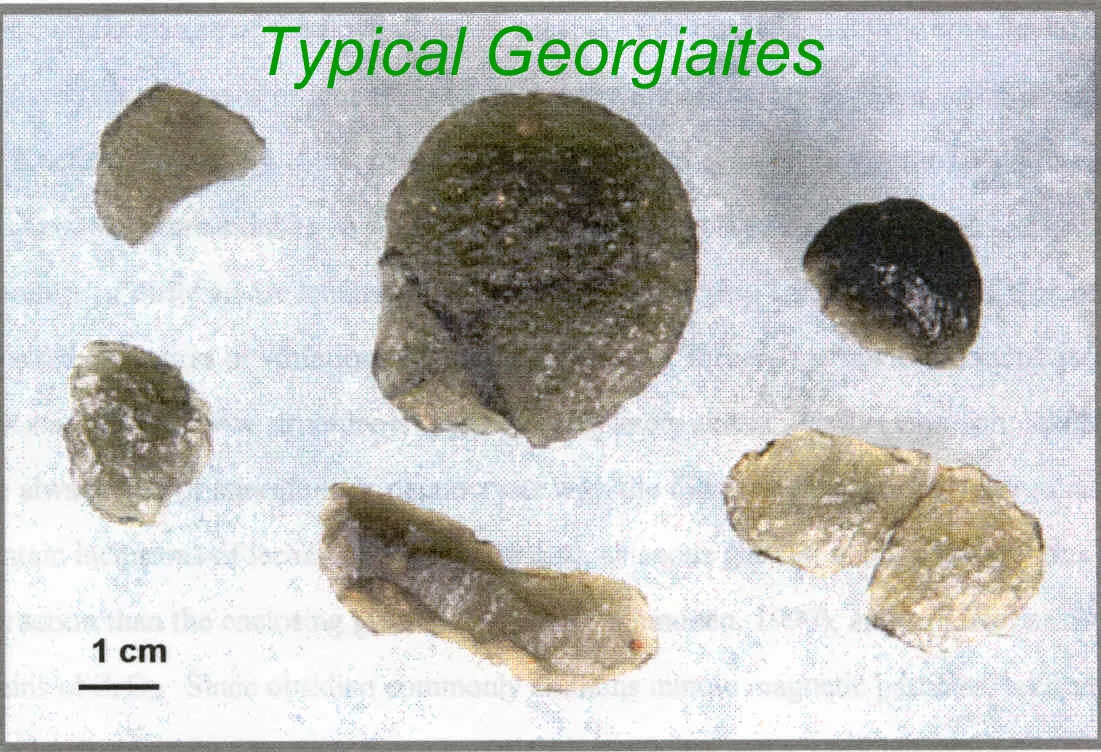
Georgiaites, or tektites, are natural glasses formed when an asteroid or meteorite collides with the earth. Many scientists believe that georgiaites formed as a result of the meteorite impact that created the Chesapeake Bay Crater in Virginia around 35 million years ago.
Photograph by Edward Albin
The New Georgia Encyclopedia does not hold the copyright for this media resource and can neither grant nor deny permission to republish or reproduce the image online or in print. All requests for permission to publish or reproduce the resource must be submitted to the rights holder.